

Exploration Metaverse
Geoscientists and mineral explorers are working in a world of increasing types, volumes and complexity of data.
The problem isn’t so much what data should we collect, but rather how do we make use of the mountains of information at our disposal and turn it into new insights and new knowledge?
This dilemma is exacerbated by the limitations of current tools to reliably, efficiently and intuitively analyse complex data, and the interoperability of our data repositories.
Virtual and augmented reality are rapidly evolving technologies that may offer novel solutions through data immersion. This approach encapsulates the concept of “space to think”, where different scales and contexts of data analysis can be bridged, intuitive gesture-based tools for data interaction can be used, and new ways of analysing information can be introduced to support rapid and informed decision-making.
As part of the MinEx CRC, UniSA's Australian Research Centre for Interactive and Virtual Environments has developed three innovative projects that use immersive technologies to work towards the goal of an Exploration Metaverse. These projects encompass augmented reality core logging (LogAR), virtual collaboration and visualisation of spatial datasets (OzMap), and immersive analytics for geoscientific data (ImAxesGEO).

.png)
LogAR
Pioneering the future of drill core logging with in-situ data visualisation and immersive toolsets.
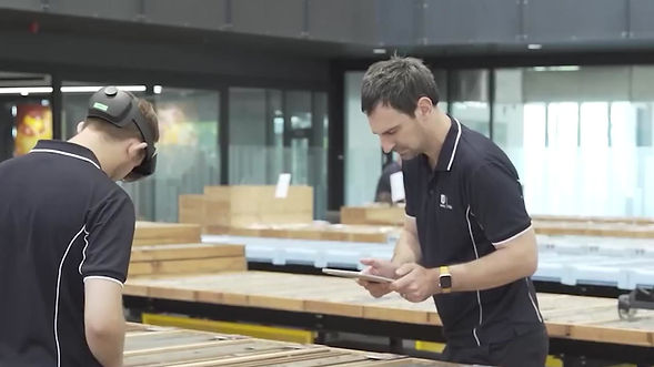
Drill core logging is dominated by traditional practices such as pen and paper logs and cumbersome spreadsheets. Critical contextual information is often buried in databases and printouts that are rarely referred to. Logging standards can vary between organisations and individuals leading to inconsistencies in data output and poor archiving practices, and valuable time is burned on data entry and conversion.
LogAR is a prototype multiplatform application that enables borehole logs and supporting datasets to be seamlessly created and visualised in-situ using augmented reality. Our aim is to improve logging efficiency and accuracy by going beyond simply observational insights to using all available borehole datasets to inform decision-making. Watch the development snapshot video below to see the platform in action, and witness how it will provide brand new insights for users by leveraging total data interoperability.
.png)
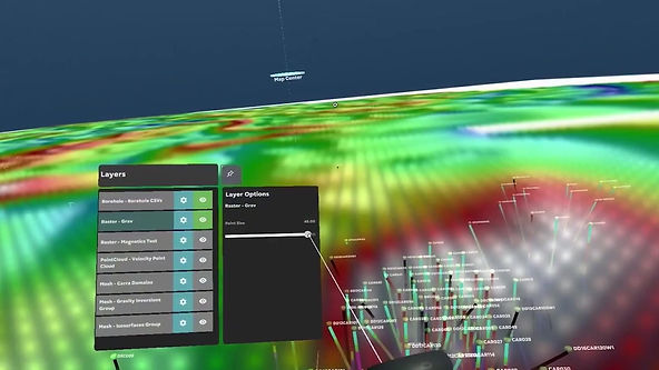
OzMap
Immerse yourself in a collaborative virtual environment capable of visualising industry-standard exploration and spatial datasets.
While virtual reality offers new ways to visualise, interact with and collaboratively analyse data, the platform's value is diminished without the capability to handle real-world production and modelling information in a frictionless manner. OzMap is an open-source VR application allowing multiple users to collaboratively visualise and annotate industry-standard exploration and spatial datasets in an immersive environment.
OzMap works with common data types including borehole logs, point clouds, raster imagery and meshes. Data visualisations, mapped to a dynamic 3D model, empower the user to view their data at any scale and perspective. As shown in the development snapshot video below, multiple users can simultaneously view and annotate the virtual scene, enabling an novel way to immersively collaborate and present data to team members and stakeholders.
OzMap was developed in partnership with OZ Minerals as a 12-week research program supported by the Think and Act Differently (TAD) initiative.

ImAxesGEO
An immersive VR system for exploring multivariate data using fluid, modeless interaction.
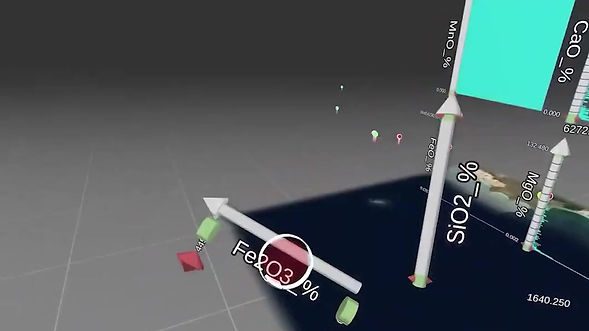
What if multivariate data visualisation and analysis was as simple as physically connecting two virtual axes together? What if new insights from complex geochemical or petrophysical datasets could be gained in a more natural and intuitive way? Building on open-source frameworks, ImAxesGEO is an immersive system for exploring multivariate data using fluid, modeless interaction.
Loaded via simple CSV files, data attributes are embodied in ImAxesGEO by interactable axes. These axes can be freely grabbed, thrown and snapped together to form 2D and 3D scatterplots and matrices, parallel plots and histograms, while data points can also be plotted and geospatially correlated on a 3D map. By enabling data visualisations to be rapidly created and combined in this natural manner, ImAxesGEO enables the user to focus on exploring and communicating their data in their own "space to think", rather than dealing with clunky spreadsheets and non-intuitive input methods. See how immersive analytics can change the way you visualise and interpret complex data via the development snapshot video below.
More Information
The research projects on this page were proudly developed through a partnership between the MinEx CRC and the Australian Research Centre for Interactive and Virtual Environments (IVE). Find out about the MinEx CRC Research Programs at MinExCRC.com.au and about IVE at unisa.edu.au/research/IVE.


